Flight Simulator Bing Maps – Exploring the Potential of 3D Mapping Data:

Microsoft’s well-liked flying software becomes more than just a game thanks to the 3D mapping, data, and expert advice from avionics makers.
“Hey, that’s my house, I can see it from here in the air!”
In the new version of the restored classic Microsoft Flight Simulator, I was banking a little turboprop aircraft above my neighborhood. It’s an old joke that you’d hear it from someone bouncing on a trampoline, but that’s what went through my mind.
Because my home was in fact there. … the residences of my neighbors, in addition to the nearby medical complex, the retail center, and the nearby farms. Thanks to the new program’s use of Microsoft’s extensive mapping data, everything is startlingly precise. Even the trees, fences, and other objects I am familiar with from my adventures on land were present and accurately represented in complete 3D.
What We Know So Far:

The first version of Microsoft’s Flight Simulator, which debuted in 1982 during the 8-bit era, has been in production for the longest. It just provided a green expanse of ground and a blue expanse of sky at the time, along with a gray strip that served as your runway and some black and white blocks as buildings. According to widespread opinion, Microsoft gave up on the brand in 2012 because it was too specialized a market for the multinational corporation to continue. It gave Lockheed Martin the license to use the fundamental sim technology, and Lockheed Martin uses it in learning and training environments.
Given that the business had made no announcements on the initiative, its revival this past June caught both the software and aviation industries off guard. The new game is now undergoing alpha testing and is anticipated to release sometime in 2019. But it was already obvious from the early beta that Flight Simulator might be more than just a game. It might be a useful teaching resource for aspiring pilots.
That is due to such localized details. While virtual sightseeing is entertaining, it also gives actual pilots a chance to practice navigation using the landmarks they look for when flying. The term “visual flight rules” (VFR) refers to this type of flying, which means that it does not solely rely on instruments. Also, you find your way by tracking certain buildings, roads, towers, mountains, rivers, and so on.
Accurate, simulated VFR flight allows pilots to practice their flights in advance, making the actual flights later on more comfortable, even though it cannot be utilized as a formal training tool. Real-world terrain modeling in most flight simulators puts a lot of strain on the computer and can’t keep up with a constantly changing environment. Every graphic data byte had to be saved locally in the early versions of Flight Simulator, whether it was downloaded or accessible via a DVD, CD, or, yes, a floppy disk. “This sim steps out of that model massively,” says Pete Wright, a pilot whose YouTube channel, Frooglesim, focuses on evaluating such software. It’s breathtaking. It’s incredible.
The Technology:

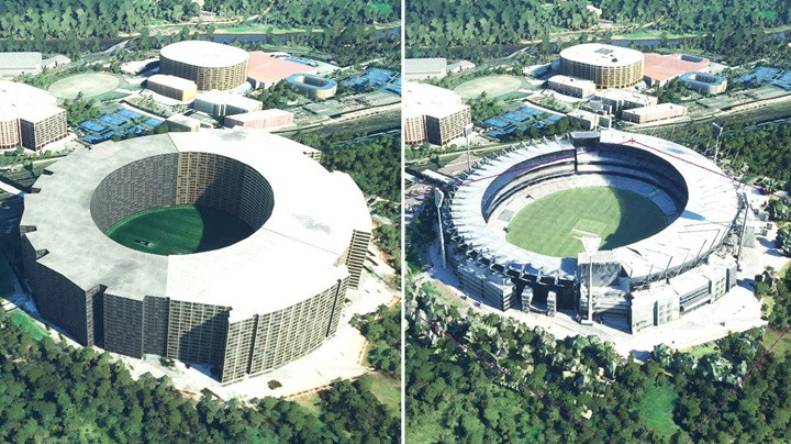
What has changed with the latest version of Flight Simulator is Microsoft’s creation of their rival to Google Maps. The 3D information for the game comes from Bing Maps, which pulls exact information for any location in the world from the cloud and renders the images locally. The outcome is a virtual environment that matches the accuracy of the most recent Bing data.
In actuality, the Bing connection served as the catalyst for the entire endeavor. The resurrection, according to Jorg Neumann, head of Flight Simulator, started with an app he was creating for Microsoft’s HoloLens augmented reality glasses. We wanted users to be able to utilize the goggles to take tours of any location in the world, according to Neumann. The rendering capability was ready five years ago since it utilized data from Bing. We began working seriously on implementing that concept into a new flight sim two years later.
The Flight Simulator was created by Microsoft in collaboration with the French video game studio Asobo Studio, with input from pilots and the community of flight-sim users and developers who continue to use the original software. To make sure that the flying experience is as accurate as the graphics, it incorporated information and technical advice from aircraft and avionics makers. It had 40,000 airports from all over the world, each with realistic buildings, runways, and taxiways, as well as directional marks.
Even in dense cities, the buildings up close seem photo realistic thanks to realistic weather scenarios produced from the real-time data. I drove through New York City expecting to see a smudgy 3D image similar to what you may see when zooming in on a target in Google Maps. But everything is expertly done, even down to street level architecture details. The simulator still allows offline game play with drastically degraded visuals and will still automatically adjust to the available internet speed. Users can still get the complete experience even without connectivity by downloading certain tiny sections.
While Sebastian Wloch, CEO of Asobo, claims that the game play will be just as enjoyable on less powerful rigs, it certainly helps that I have a strong gaming PC and a widescreen monitor. That is because of what he refers to as deferred rendering. According to Wloch, “twenty years ago, you would render one tiny piece of an airplane and do all the lighting and shadows on it at the same time.” We can now give each piece a memory of how it appears and postpone lighting and reflections until the last stages of rendering. This greatly speeds it up because the visual consistency of the environment is quite strong. In other words, the graphics rendering process no longer necessitates complete element reconstruction every millisecond.
Conclusion:
Nowadays, desktop flight simulators can genuinely play a big part in flying instruction, as Laminar Research’s X-Plane, Microsoft’s main rival, demonstrates. The program’s high-quality aircraft and flight modeling have earned it FAA certification for use in various types of classroom training. However, X-Plane employs automatically produced scenery instead of the graphics capabilities Microsoft is releasing. These buildings and trees are largely random and typically resemble urban, suburban, and rural landscapes. (More precise digital models are available for download separately from third-party developers.) Another benefit of X-Plane is its incorporation of virtual reality operation via goggles, which is a perfect fit for flight simulation. Microsoft won’t provide that at launch, but Neumann claims it will.
Both Neumann and Austin Meyer, the creator of X-Plane, claim they are prepared to respond to the impending era of electric vertical-lift aircraft, complete with intricate multi rotor power trains and computer-assisted flight capability. Aviation aficionados will be able to test-fly an air taxi at home before boarding and view their homes from above as those electric aircraft expand throughout the ensuing decades.
That’s it. I hope you’ve enjoyed reading this article. What’s your experience with Bing Maps on Flight Simulator? Feel free to share it in comments below and I would be happy to read it and get back to you.
Thank you and see you soon in the next article!

As an aviation enthusiast, I thoroughly enjoyed reading your article on the captivating world of 3D flight simulators. The article does a fantastic job of showcasing the immersive and realistic experience that these simulators offer, taking users on an exhilarating virtual journey through the skies.
Your description of the cutting-edge technology used in 3D flight simulators is both informative and engaging. The way you explain how the combination of high-resolution graphics, advanced physics engines, and realistic cockpit controls creates a truly authentic flying experience is commendable. It paints a vivid picture in the reader’s mind, sparking a sense of excitement and curiosity.
Thanks for the feedback and thanks for reading the articles. Flight Simulator are created for those who want to fly virtually. It always get improved with new versions.
After reading the article on “Flight Simulator Bing Maps 3D Mapping Data” I’m intrigued by the integration of Bing Maps’ 3D mapping data into flight simulators. The concept of having accurate and realistic mapping within the simulator environment sounds fascinating.
One question that arises for me is how exactly Bing Maps’ 3D mapping data is incorporated into flight simulators. Are there specific software or tools that facilitate this integration? I’m curious to know more about the technical aspects of how the data is utilized to create an immersive and realistic flying experience.
Additionally, I wonder about the extent of coverage provided by Bing Maps’ 3D mapping data. Does it encompass a wide range of regions and airports worldwide, or are there limitations to certain areas? It would be interesting to learn more about the scope and availability of this data for flight simulator enthusiasts.
The article mentions the benefits of using Bing Maps’ 3D mapping data, such as improved navigation and situational awareness. I’m curious to know if there are any additional features or functionalities that this data enables within the flight simulator environment. How does it contribute to a more authentic and immersive experience for users?
As a reader who is interested in flight simulators, this article has sparked my curiosity about the possibilities and advancements in the field. I appreciate the writer’s summary, which highlights the importance of Bing Maps’ 3D mapping data in enhancing the realism and overall quality of flight simulation. I look forward to exploring more resources and discussions related to this topic.
I invite fellow readers and enthusiasts to share their experiences or insights on the integration of Bing Maps’ 3D mapping data into flight simulators. Let’s engage in a conversation and delve deeper into the technical aspects, benefits, and potential future developments in this exciting realm of simulation technology.
Bing map comes with Microsoft Flight Simulator 2020. You just need Flight Simulator 2020 to access the bing map software. Bing maps provides detailed cities and scenery around the world. I think extra features can be added with add ons. Using bings maps will help users to navigate and experience the world. Thanks for the feedback.